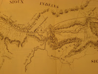
 The detail which appears on the left (similar to the detail used on the postcard for Dave Burrell’s up-coming performance at the Rosenbach) is from Charles Preuss’s map of the road from Missouri to Oregon.
Orinigally published in 1846 this series of 7 maps details the journey west, from safe watering holes and good hunting spots to hostile natives and steep inclines.
Early wagon trains west were often quite large, with 50-60 wagons carrying whole lives west. Some wagon trains contained as many as 300 people. Many of these “moving cities” had to set up interim traveling governments in order to keep organized and civil.
Rosenbach Museum & Library Musician-in-Residence Dave Burrell has composed 5 original pieces of music to narrate a journey west. One of the compositions evokes the trials of the wagon train members meandering west, another the rapids and serene pools of the Snake river and a third the voyage around the cape and on to Astoria through the lapping waves of the Pacific ocean.
It is hard to imagine such wilderness now, but Dave Burrell’s pieces bring you very close.
